The Great Deluge and the Coming ARkStorm
California's 1862 Megaflood, Atmospheric Rivers, and the Doubling Odds of Catastrophe
The Blind Spot of the Golden State
Ask anyone in California what natural disaster they fear most, and they will give you the same answer: The Big One. We drill for earthquakes, reinforce bridges against tectonic fault ruptures, and monitor the San Andreas with laser seismometers.
Yet the geologic and historical record tells a startlingly different truth. California's true existential hazard does not rise from the rock below. It arrives silently across thousands of miles of open ocean, packed with more freshwater than fifteen Mississippi Rivers combined, and falls from the sky.
DECEMBER 1861 • THE DEEP FREEZE
The Frozen Trap is Set
The catastrophic winter of 1861–1862 was a lethal two-act tragedy. The opening chapter, beginning in late November, was not warm, but bitterly frigid. An unrelenting storm train locked across the North Pacific into California, initiating an unprecedented 43-day storm barrage.
Because freezing levels were unusually low, these early polar-origin storms dropped their moisture not as rain, but as blinding snow across the mountains. Week after week, relentless blizzards buried the Sierra Nevada under an immense 10-to-15-foot snowpack, whitening even the foothill valleys. Billions of tons of water were locked away in ice—a colossal, primed trap waiting for a heat source.
JANUARY 1862 • ENTER THE PINEAPPLE EXPRESS
The Rain-on-Snow Cascade
Right around Christmas, the planetary steering currents shifted violently. The cold polar track gave way to a colossal subtropical Atmospheric River tapping deep into warm equatorial moisture near Hawaii—the phenomenon historically dubbed the “Pineapple Express”.
Temperatures spiked dramatically across the state, driving the freezing level skyward from near sea level to over 8,000 feet. Instead of snow, this atmospheric conveyor belt poured weeks of torrential, warm tropical rain directly onto the deep, fresh snowpack.
The resulting rain-on-snow thermal melt was catastrophic: the sensible heat and condensation from the tropical downpours rapidly liquefied billions of tons of frozen snow, releasing both the rainfall and the melted snowpack into the watersheds simultaneously. Canyons became roaring sluices of water, mud, and boulders, overwhelming every river as they burst into the Central Valley all at once.
MID-JANUARY 1862 • THE INLAND SEA
A Lake Three Hundred Miles Long
The Sacramento and San Joaquin Valleys merge at the Carquinez Strait, a narrow tidal gap through which all valley runoff must escape into San Francisco Bay. Choked by unprecedented inflows and astronomical king tides, the water simply had nowhere to go.
The entire Central Valley transformed into a freshwater sea: 300 miles long and up to 20 miles wide, stretching uninterrupted from Redding to Bakersfield. Steamships sailed across what had been wheat fields and cattle ranches, navigating past treetops whose upper branches barely pierced the surface.
“The great central valley of the state is under water—a region 250 to 300 miles long and an average of at least twenty miles wide, a district of five or six thousand square miles... The city of Sacramento is submerged.”
JANUARY 10, 1862 • SACRAMENTO
The Governor in a Rowboat
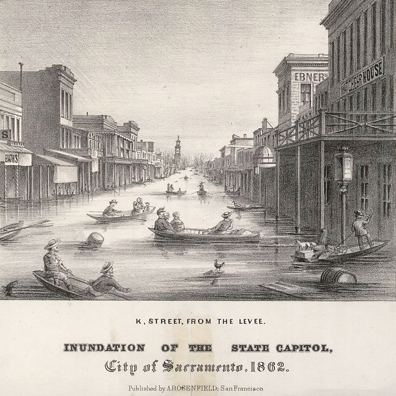
Sacramento, newly designated as California's permanent state capital, was submerged under 10 feet of brown river water. On January 10, 1862, newly elected Governor Leland Stanford walked out the second-story front door of his mansion and stepped directly into a wooden rowboat.
Two men rowed the incoming governor through downtown street canyons, past submerged telegraph poles, to the State Capitol for his swearing-in. Upon returning home, Stanford had to climb back into his residence through a bedroom window. Two weeks later, the entire California State Legislature fled to San Francisco by steamship.
“The Governor was rowed in a boat to the State House, where the oath of office was administered... K Street is navigable for boats of considerable burden.”
The Death of the Cattle Kingdom
Before the flood, California's economy was dominated by sprawling cattle ranchos established during the Mexican era. The deluge eradicated it. An estimated 200,000 head of cattle—one-fourth of all cattle in the entire state—drowned or starved on shrinking levee islands.
Across the state, one in every eight houses was destroyed or washed away—with destruction climbing to one in three homes across the inundated Central Valley. Statewide, fully one-third of all taxable property was erased from the tax rolls, plunging the infant state government into outright bankruptcy. State employees and legislators were paid in IOUs, and California was forced to reinvent its entire economy from pastoral cattle ranching into intensive grain and citrus agriculture.
The Ignored Warnings
To American settlers, the 1862 flood seemed like a cruel, unprecedented act of God. But to the Indigenous peoples of California—including the Yokuts, Miwok, and Maidu—it was no surprise at all.
Indigenous oral histories explicitly documented that the Great Valley became an inland ocean every few generations. Native communities built their permanent settlements on foothill terraces and elevated knolls, utilizing the floodwaters for tule-reed canoes and migratory waterfowl hunting. They warned early European ranchers not to build homes in the flood basins, but the warnings were brushed aside as folklore.
“In old times, the water covered all the plain from the Sierra to the Coast Range. Our old people knew the water would return, so the villages were built high on the knolls.”
PALEOCLIMATE DISCOVERY • 2,000-YEAR CORES
The Natural Clock of California
Was 1862 a freak, once-in-a-millennium anomaly? Geologists set out to test this by drilling sediment cores in the Santa Barbara Basin and San Francisco Bay mud. Because California rivers carry enormous pulses of terrigenous silt during megafloods, each event leaves a distinctive, dark sedimentary lamina.
The results from paleoclimatologists Dr. B. Lynn Ingram and Michael Dettinger were unambiguous: megafloods matching or exceeding the scale of 1862 struck California repeatedly in 212 CE, 440, 603, 1029, ~1300, 1418, 1605, 1750, and 1862.
These megafloods recur naturally roughly every 100 to 200 years. More than 160 years have elapsed since the last one. California is living on borrowed time.
USGS SCIENCE SCENARIO • THE ARkSTORM
Enter the ARkStorm
In 2011, the United States Geological Survey brought together over 100 atmospheric scientists, hydrologists, engineers, and disaster modelers to answer a terrifying question: What would happen if the 1862 flood hit the California of today?
They named the resulting simulation ARkStorm (Atmospheric River 1,000). Modern California is not the frontier territory of 1862 with 400,000 inhabitants. It is an urban powerhouse of 39 million residents, supporting the fifth largest economy on planet Earth.
“An ARkStorm is not a worst-case scenario. It is a scientifically plausible scenario of what will happen when California experiences a storm sequence equal to 1861–1862.”
Infrastructure at the Breaking Point
Modern California relies on 1,500 dams, 1,600 miles of agricultural levees, and the fragile labyrinth of the Sacramento-San Joaquin Delta to keep the sea at bay and supply drinking water to 25 million people.
In an ARkStorm, key reservoirs like Oroville and Folsom fill to maximum surcharge capacity in days. Spillways must dump hundreds of thousands of cubic feet per second directly into aging river channels, triggering catastrophic levee breaches throughout the Central Valley and saltwater intrusion across the Delta aqueduct system.
ECOLOGICAL ANALYSIS • THE TOXIC INLAND SEA
The Toxic Deluge: Modernity's Environmental Toll
In 1862, the flood submerged an unengineered frontier of wild grasslands, tule marshes, and cattle pastures. A 21st-century deluge would drown an intense industrial, petrochemical, and chemical-intensive agricultural empire, creating an unprecedented modern ecological catastrophe.
Across the valley floor, active oil extraction fields, refinery sumps, and chemical storage depots would be submerged alongside over 1,300 industrial mega-dairies and feedlots, flushing millions of gallons of crude oil, benzene, synthetic pesticides, and raw manure into the floodwaters. Worse, raging floodwaters would scour and remobilize millions of pounds of toxic Gold Rush mercury buried in Sierra riverbeds since the 1850s.
As this toxic cocktail drains through the Carquinez Strait, it would trigger massive hypoxic “dead zones” in San Francisco Bay, decimate endangered salmon runs, and contaminate the Delta aqueducts that supply drinking water to 25 million Californians.
MACROECONOMIC ANALYSIS • $1.2+ TRILLION
A Trillion-Dollar Shock & National Food Crisis
The updated ARkStorm economic modeling produces figures that dwarf every natural catastrophe in American history: projected direct property damage and business disruption exceed $1.2 to $1.4 Trillion—roughly one-third of California's entire annual economy.
To put that astronomical sum in context: $1.2 Trillion is six times costlier than Hurricane Katrina, eight times Hurricane Harvey, and four to five times the devastation of a modern recurrence of the 1906 San Francisco Earthquake. In fact, an ARkStorm would equal or exceed the combined cost of every U.S. natural disaster over the past decade combined.
While 1.5 million Californians would require evacuation, the most dangerous long-term shockwaves would strike far outside state borders. The flooded Central Valley is America’s agricultural engine, producing over one-third of the nation's vegetables, three-quarters of its fruits and nuts, and 80% of the entire world's almonds.
With millions of prime agricultural acres submerged for up to six months, entire seasonal harvests would be wiped out, causing immediate nationwide supermarket shortages and runaway food inflation. Worse, drowned fruit and nut orchards take 5 to 7 years to replant and reach commercial maturity—turning a single winter deluge into a multi-year national food crisis, compounded by severed transcontinental rail lines and interstates.
THE CLIMATE MULTIPLIER • THERMODYNAMICS
The Clausius-Clapeyron Firehose
The natural 150-year megaflood clock is alarming on its own. But we no longer live in the pre-industrial climate that produced 1862. Fundamental atmospheric physics governs how much water a storm can transport.
Under the Clausius-Clapeyron relation, for every 1°C of atmospheric warming, air holds roughly 7% more water vapor. As the tropical Pacific heats up, atmospheric rivers absorb exponentially more moisture, transforming into superheated vapor conveyor belts with integrated moisture transport previously unseen in modern meteorology.
SCIENCE ADVANCES (2022) • ARkSTORM 2.0
The Snowpack Is No Longer a Shield
In historical California winters, the Sierra Nevada served as the state's greatest natural defense: by freezing precipitation above 4,000 to 5,000 feet, the mountains captured over half of a storm's water as solid snow. This delayed runoff until the gradual spring thaw, shielding the valleys from having to absorb an entire winter's precipitation at once. (Even in 1861–1862, that frozen shield held back trillions of gallons through December before an extraordinary tropical warm surge breached it.)
In 2022, climate scientists Dr. Daniel Swain and Dr. Xingying Huang published landmark research in Science Advances modeling ARkStorm 2.0 with high-resolution coupled atmospheric models. Their crucial discovery was that in a warmed climate, this protective mountain shield permanently collapses.
Because climate warming pushes the Sierra freezing elevation 3,000 to 5,000 feet higher, precipitation that historically accumulated safely as frozen snow now falls as warm driving rain across virtually the entire range from day one. Without the snowpack to buffer and delay the deluge—and with torrential rain rapidly melting whatever transient snow does exist—peak river runoff into the Central Valley explodes by an astonishing 200% to 400%, overwhelming dams and bypasses designed for an era when the mountains still held the water back.
PROBABILITY DYNAMICS • THE NEW REALITY
From Rare Freak to Generational Certainty
In the pre-industrial world, an ARkStorm megaflood was a 1-in-200-year event (0.5% probability per year). Swain and Huang demonstrated that climate change has already increased the odds by ~50%.
In a world warmed by +2°C to +3°C, the likelihood of a California megaflood doubles to triples: shrinking the recurrence interval down to 1-in-50 or 1-in-35 years. Over an average human lifetime in California, living through a catastrophic megaflood shifts from a remote risk to an 80%+ statistical near-certainty.
ENSO TELECONNECTIONS • THE SEASONAL CATALYST
The Super El Niño Multiplier: Why This Winter Spikes the Odds
While greenhouse gases steadily compress California’s multi-decadal baseline return interval, year-to-year danger is governed by the wild heartbeat of the tropical Pacific: the El Niño–Southern Oscillation (ENSO).
In ordinary winters, the North Pacific jet stream meanders, often splitting or steering storms north into British Columbia. But during an extreme Super El Niño—when sea surface temperatures along a 6,000-mile equatorial corridor surge +2.0°C to +3.0°C above normal—the entire atmospheric circulation of the Northern Hemisphere reorganizes.
Tropical deep convection strengthens and straightens the North Pacific Subtropical Jet Stream into a roaring 250-knot atmospheric firehose, aimed like an arrow directly at California. The historic 1861–1862 deluge itself struck during an extraordinary, record-warm El Niño winter; modern super events in 1982–83, 1997–98, and 2015–16 produced the most destructive winter barrages in modern memory.
When an active Super El Niño coincides with baseline ocean thermal anomalies, atmospheric rivers tapping into tropical heat can carry unprecedented vapor fluxes. Climate dynamicists estimate that in a Super El Niño winter, the single-season probability of an ARkStorm-magnitude sequence jumps by 300% to 500%—turning a statistical concern into an acute, immediate seasonal reality.
Interactive Climate & Risk Simulator
Explore the compounding cascade of California flood risk
Adjust the sliders below to see how long-term global warming combines with seasonal El Niño ocean anomalies to supercharge atmospheric rivers and elevate this winter's flood odds.
Living With the Water
We cannot concrete our way out of atmospheric rivers. Trying to build 50-foot river levees simply concentrates hydraulic pressure until inevitable failure occurs. Instead, California’s most brilliant engineering successes have come from giving the river room to breathe.
The Yolo Bypass—a vast 59,000-acre agricultural and wetland floodplain west of Sacramento—safely diverts 80% of floodwaters around the state capital during high water. In 1997, 2006, and 2017, the bypass saved Sacramento from repeating the disaster of 1862.
The future of flood defense lies in expanding these bypasses and implementing Flood-Managed Aquifer Recharge (Flood-MAR): channeling winter flood flows onto farmland to recharge overdrafted Central Valley aquifers, turning the threat of deluge into long-term insurance against inevitable summer drought.
The Atmospheric Inevitable
California was born in water and shaped by drought. For a century, we treated the deluge of 1862 as an embarrassing historical relic of an unengineered past. But nature does not forget its watersheds.
The water will come again. As greenhouse gases warm the Pacific and push atmospheric rivers to unprecedented extremes, the question is no longer whether an ARkStorm will arrive, but whether we will have the wisdom to prepare before the skies open.
“All of this infrastructure was designed for a climate that no longer exists. Surviving the 21st century means remembering the water of the 19th.”
The Resident’s Survival Blueprint: Preparing for the Deluge
While state and federal agencies reinforce levees and widen flood bypasses, individual survival during a modern ARkStorm hinges on household readiness. Atmospheric rivers can knock out power grids, sever interstate highways, and contaminate municipal water treatment plants, isolating communities for days or weeks.
Every household in California—from coastal valleys to Central Valley floodplains and Sierra foothills—should maintain a comprehensive 72-Hour to 2-Week Survival Kit:
- Potable Water: One gallon per person per day for at least 7 to 14 days, stored in heavy-duty food-grade containers, alongside chemical purification tablets or filters.
- Off-Grid Communications: A hand-crank NOAA Emergency Weather Radio with solar charging to receive evacuation directives when cellular towers lose power.
- Sanitation & Medical: A trauma first-aid kit, a two-week surplus of vital prescription medications, and emergency dry sanitation supplies.
- Flood Insurance: Standard homeowner insurance policies exclude flood damage. Securing a National Flood Insurance Program (NFIP) policy 30 days before storm season is essential—even outside high-risk FEMA zones.
- Go-Bag & Evacuation Route: Pre-staged waterproof backpacks with waterproof copies of vital documents, cash, flashlights, and two distinct pre-mapped overland escape routes away from low-lying delta or canyon washouts.
Knowing your watershed’s elevation, signing up for county emergency reverse-911 alerts, and elevating household utilities off ground level transform vulnerability into resilience.